Please wait a moment while we load the next section.
Section 1: Naming the Settlement


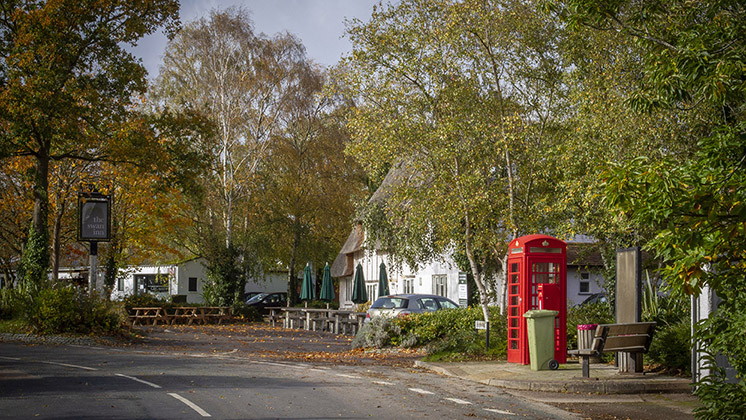
Waterbeach appears in the 1086 Domesday Book as Utbech and the connection and differences between Landbeach and Waterbeach have been a fundamental defining factor throughout the centuries.
The area defined by the name has been consistent due to natural and historic features: stretching to the River Cam to the east, and Car Dyke and Akeman Street to the west. The northern boundary with Denny Abbey and Chittering to the north links to drainage ditch divisions with their roots in the 12th to 13th Century.
The boundaries remained consistent throughout the drainage of the fens, enclosure and the hundreds of years of farming, living and working that has occurred across this area.
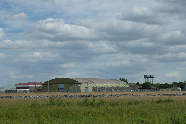
The only subdivision of this land came with the Second World War and the subsequent use of part of the allocated area as first an Airfield for the RAF (as RAF Waterbeach) then in the 1960s the Royal Engineers, updating the name to Waterbeach Barracks.
The military legacy is important here: wartime and postwar activities left behind barracks buildings and the airfield but, more significantly, more deep rooted connections in the form of the Memorial Garden by the lake, graves in the Village Cemetery and the Waterbeach Military Heritage Museum.
These bind the link between the Barracks and village. Alongside that, the nature of the Barracks meant that many village residents were regular visitors and users of the facilities, notably the Swimming Pool, the Sports Hall, Golf Course and Lake. The Royal Engineers were in turn actively involved in supporting the village, with events like the Feast, and many veterans remain in touch and share memories which is helping inform recording of the heritage of the site and influencing future approaches set out in this strategy.
This interaction has been a key theme recounted in residents’ stories of when the Barracks was operational. Similarly the land to the east that makes up Waterbeach New Town East, has been farmed continuously through this period, almost exclusively by local families.
Unusually, the new town has not been subject to the same processes as the aborted “Mereham”, or the delivery of Cambourne or Northstowe – where a new name and identity was established at an early stage and carried through to provide the moniker for the new community on the ground.
The early promotion of Northstowe was linked to several existing places, not one - Longstanton and RAF Oakington, both abutting, and close to Oakington village and Westwick. It always had its own identity, hence a new name was adopted. Cambourne had no close association with an existing settlement.
One reflection on this, is that there has always been an understanding that the roots of Waterbeach New Town are in the existing village, and the ambition from the initial stages of vision-making, was to “grow a place, from the existing village”, protecting and enhancing the village’s historic setting.
A quick summary of key planning history includes:
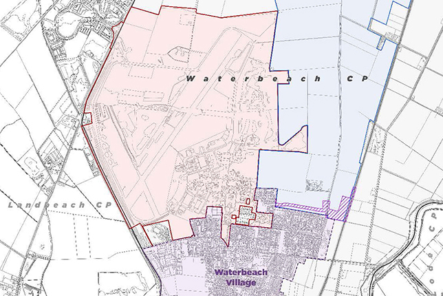
Planning proposals for the Waterbeach Barracks & Airfield and Waterbeach New Town East
The origin and evolution of place names is more often than not rooted in physical and natural features and/or strong associations with human activity; names invariably relay a sense of place and history. There is also a linguistic dimension with names being shortened/adapted to suit contemporary language and ease of reference. This tends to favour simple names that roll off the tongue, have positive connotations and are easily spelt/pronounced. The anomalies and the exceptions are of course notable and valued where they do not conform to these conventions.
Fanciful names (marketing hyperbole) rarely sit comfortably upon real places, especially in circumstances where a new community is to be created. A sense of belonging is far more readily achieved by looking to the existing naming conventions of the location.
Large settlements usually carry the names of the earliest habitation, the first kernels of the place, which might have been a crossing/meeting point, farmstead or small hamlet. Often there is a pride in a long history of organic growth and change from a modest beginning.
In naming planned settlements there is similar comfort and pride in starting with the existing. There is benefit in terms of familiarity and identity in adopting the name of an existing place that will become part of a larger whole.
This not only resonates with the growth of organic settlements, grounded in historical association, but respects the fact that it is inappropriate and difficult to impose a new identity on a place that is already known and familiar. It is important, nevertheless, to consider the identity of existing places which become enlarged or incorporated; especially where those places offer richness, diversity, and historical touchstones. It is likely that these places will remain distinct and identifiable, in their own right.
There is very good precedent for this approach in planning/naming new communities.
There are a range of other factors that influence naming which are important to consider. These are set out below:
It is difficult for developers and promoters to seek to impose names, especially as they are often influenced by marketing priorities. The process must be taken forward with local communities and their representatives, and key stakeholders, to agree an approach which is appropriate. Where places already have a strong association with a name it is also extremely difficult to effect change; familiar, regularly used names tend to persist and attempts to impose change are resisted or cause division. Names matter beyond the notation on a map because they are the most obvious signal of identity and association.
The linkage between the village and the Barracks is a long standing and important one. The connections between the village and the proposed development is to be further reinforced through provision of a range of new shared facilities which will be based in or serve the new development, but will also serve the wider population. These include:
Similarly, care is to be taken not to duplicate services and facilities available in the village so mutual benefit and patronage is maximised.
The prospective new development is very distinct in terms of character from the village, but functional connection and human interaction will inevitably be very much intertwined, and likely to become more so over time. Throughout the scheme development and consultation there was a fine balance which all were keen to maintain, indeed celebrate, between preserving the identity and character of the historic heart of the village, and providing new facilities and amenities which serve the village and incoming residents. Good and early connections to new facilities and those in the village has been key. It is important to try to think ahead to how the community will in time relate to the place and each other.
The arc of development, which has come to define the first phase of development on the Barracks and Airfield site north of the lake, was part of working through a challenge from a number of local stakeholders that first development should happen directly to the north of the village in the Barracks, to enable that sense of a growing village expanding to the north. There are many reasons why early development is progressing first around the lake, but connecting the two areas physically by connection and culturally with the Waterbeach community identity has been important to the village and is key to the broader shared vision.
We know one of the key concerns around naming comes from traffic management and control, and therefore while this is not a clear strand of culture and identity, this is a key concern around routing people appropriately to the key locations from outside the area. This will require a signage strategy which reflects the broader naming strategy, when agreed, and avoids harmful impacts from traffic mistakenly diverting through the village.
The opportunity to sign and put in place gateway features on Denny End Road, Cambridge Road and Clayhithe Road which clearly mark the historic village can come forward as part of the public realm enhancements project, being funded by the S106 agreements.
Signage
New entrances being installed on the A10 have limited vehicle access to the village in the first instance. Furthermore both developments have committed to traffic control measures being in place which prioritise cycle, walking and public transport connections to the village, and inhibit vehicular access.
These new entrances will also be heavily signed as construction entrances and then with signs, branding and flags to support the first house sales as the new homes move into sales and then are occupied. At that stage the more permanent signage approach will need to be in place.
This will also relate to signing access to Waterbeach New Town East - which will be through the Barracks and Airfield site.
Roundabout naming
The approach to naming also provides an opportunity to review key connections to the wider infrastructure, for example looking at naming roundabouts on the A10 at key entrance points. This would not only enable clarity but also create a sense of place, which will introduce a fine grained distinction between different parts of the settlement. For example, what has become known as Cambridge Research Park Roundabout by default, could become Templars or St Clare’s, and the planned Southern Roundabout connection on the A10 should come forward with a name which grounds it in its location and the places it connects.
The existing governance implies that the whole area is Waterbeach, given that this entire area is covered by Waterbeach Parish Council. This will continue in the short and medium term with a community governance review likely to come forward once the first residents are in place. The potential remains for a Community Association or Trust to be taken forward with early residents to support their active engagement in community events, activities and spaces on the new development, while discussions continue to ensure appropriate future robust governance which can support the shared facilities across the new and existing communities.
Naming a planned settlement is an interesting challenge, but an important one to get right. It helps to reinforce character and ground a new community.
Experience in Milton Keynes offers some useful and direct parallels with circumstances around the new town at Waterbeach.
Although it was a designated new town of significant scale (substantially bigger than the Waterbeach new town) and is now a selfproclaimed city, the approach to naming is transferable.
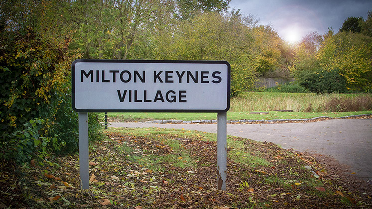
‘Milton Keynes’ existed as a village long before the new town, and became part of the greater whole. With its own signposts and gateway features, the village has maintained a sense of distinction from the larger new development, without creating a divided place.
The example there has ensured the older village has developed a positive reputation as a premium location, with historic properties and character, but good access to facilities and amenities of the new town.
The designated area of Milton Keynes incorporated great swathes of countryside but also infilled between four existing towns and incorporated many characterful Buckinghamshire villages. The historic villages each became the focus of a new grid square with sensitive and varied approach to integration.
The city was named after one of these villages. Historically, the village was known as Middeltone (11th century). After the Norman invasion, the de Cahaines family held the manor within the village until the 13th century.
The village became known as Middleton de Keynes, eventually being shortened to Milton Keynes. The city grid square in which the village is now located was named Middleton, with reference back to this time.
In deciding upon the name for the new city, Labour Minister Dick Crossman apparently alighted on the village when looking at the map and noted the parallel with John Milton, the poet, and John Maynard Keynes, the economist. This provided a firm connection with the existing place combined with an expression of ambition in terms of “planning with economic sense and idealism”. It suited very well.
The village has retained a distinct identity within the city. It is known as Milton Keynes Village within Middleton grid square. It is a very desirable and popular place to live (reflected in elevated property values) combining a quaint village character with city amenities on the doorstep.
This survey has now closed.
Privacy Policy
Your information will only be used to contact you about the next steps of this consultation. At the end of the consultation you will be given a choice if you want to receive information about the development going forward or not and if you do not your data will be deleted. Please click the link below to see full details of our Privacy Policy
Caption Here